Conference by Mandy Lombard – How to design a Marine Protected Area?

May 4th, 2022, R/V Marion Dufresne, Mozambique Channel
Author: Lea Nupnau
Professor Amanda Lombard is a researcher in Marine Spatial Planning at Nelson Mandela University. With her 30 years of experience in local, national and international conservation planning and assessments, Mandy spoke to us during her seminar on board the Marion Dufresne about conservation planning and the creation of a Marine Protected Area (MPA). In particular, she illustrated her seminar with the example of the 20 new South African offshore MPAs she has worked on over the past two decades.
The ocean has been supporting the livelihood of humankind for ages by producing 50% of the oxygen that we need to breathe, by absorbing CO2 emissions and heat from the atmosphere, or by supporting marine and terrestrial ecosystems. The latter ones, when in healthy condition, may provide in turn ecosystem services such as food sources, coastal protection and valuable genetic diversity for bioprospection.
We as humans are using the ocean with increasing intensity for transport, recreation and as food source. Thus, overfishing, pollution, habitat destruction, and impacts of climate changes such as ocean warming and ocean acidification have altered and continuously downgraded the marine ecosystems over the past years compromising the functioning of ecosystems and their services.
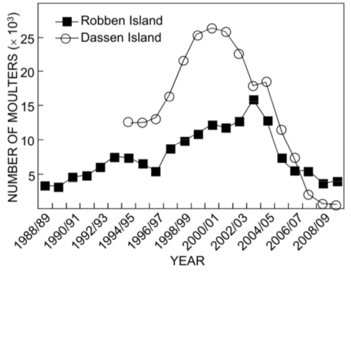
There are many examples that demonstrate the destructiveness of human activities such as the reduction of global mangrove forest by 70% or the depletion of pacific bluefin tuna by 97%, bringing them almost to extinction. In South Africa alone, overfishing, and changes in the environment and ecosystems due to for example harmful algae blooms caused several marine species populations to collapse, affecting the whole food chain. Among these species are the red lobster, eastern cape squid and penguins. The collapse of African penguins since the early 21st century is particularly impressive (figure on the right).
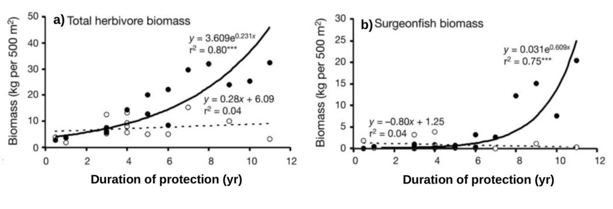
One toolbox to conserve and protect marine ecosystems and species are marine protected areas (MPAs). They have been proven to be an effective tool to prevent pressures like fishing or overfrequentation and the subsequent degradation of ecosystems. At the same time, this protection status promotes the restoration of the respective ecosystems, thus ecosystem services become more effective once again, resulting in return of investments between 1:3 up to 1:20; the most effective MPAs being no-take zones (i.e. zones in which the extraction or destruction of natural resources is totally forbidden). As for instance, the figure below shows the exponential increasing in fish biomass in function of the duration of the protection from 15 no-take MPAs.
In order to ensure the success and allow the evaluation of the efficiency of an MPA, it has to be designed to serve specific relevant conservation purposes, so-called conservation objectives. The objectives are to be adapted to each region and its pressures, requiring individual conservation planning for each area of interest.
Conservation planning requires the assemblage of as much information about the area in question as possible. The information are retrieved/acquired from different sources such as observation, modelling and combinations of both. The bathymetry, benthic maps, oceanographic conditions, observations of various parameters and small organisms up to top predators and fishing efforts are valuable information that are used to create habitat utilization maps. In addition to this, cost layers are created which indicate the intensity and importance of human activity in the different zones of interest as they usually are in conflict of interest with the creation of an MPA.
When establishing MPAs one of the principal goals is to cover a large diversity of habitats (pelagic, benthic,..) all the while considering the importance of some areas for human use. To identify areas relevant to reach the conservation objectives conservation planning softwares (e.g. Marxan) allow the creation of selection frequency maps. In order to know why certain areas are considered more important than others in the selection frequency maps, focus area maps are created which can be used as an argumentative tool during stakeholder meetings which are required to set in place an MPA and ensure that the new regulations are going to be respected.
As the planification of MPAs requires the assemblage of many different data points in the first place and the subsequent consultation with stakeholders, the process can take several years. In the example of South Africa, the designation of the last MPAs (figure below) will bring more than 5% of the South African exclusive economic zone under protection.

Bibliography:
Crawford, R. J. M., Altwegg, R., Barham, B. J., Barham, P. J., Durant, J. M., Dyer, B. M., … & Whittington, P. A. (2011). Collapse of South Africa’s penguins in the early 21st century. African Journal of Marine Science, 33(1), 139-156.
Stockwell, B., Jadloc, C. R. L., Abesamis, R. A., Alcala, A. C., & Russ, G. R. (2009). Trophic and benthic responses to no-take marine reserve protection in the Philippines. Marine Ecology Progress Series, 389, 1-15.
 Attention, vous utilisez un navigateur peu sûr !